


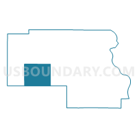
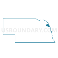
Pender Precinct, Thurston County, Nebraska
About
Outline

Summary
| Unique Area Identifier | 613984 |
| Name | Pender Precinct |
| County | Thurston County |
| State | Nebraska |
| Area (square miles) | 30.11 |
| Land Area (square miles) | 29.93 |
| Water Area (square miles) | 0.18 |
| % of Land Area | 99.41 |
| % of Water Area | 0.59 |
| Latitude of the Internal Point | 42.12647360 |
| Longtitude of the Internal Point | -96.67731790 |
Maps

Graphs
Select a template below for downloading or customizing gragh for Pender Precinct, Thurston County, Nebraska


Neighbors
Neighoring Voting District (by Name) Neighboring Voting District on the Map
- Bancroft, Cleveland & Neligh Precinct, Cuming County, NE
- Bryan Precinct, Thurston County, NE
- Flournoy/Merry Precinct, Thurston County, NE
- Thayer Precinct, Thurston County, NE
Top 10 Neighboring County Subdivision (by Population) Neighboring County Subdivision on the Map
- Pender township, Thurston County, NE (1,162)
- Bancroft township, Cuming County, NE (668)
- Flournoy township, Thurston County, NE (296)
- Cleveland township, Cuming County, NE (181)
- Thayer township, Thurston County, NE (125)
- Bryan township, Thurston County, NE (110)
- Merry township, Thurston County, NE (76)
Top 10 Neighboring Place (by Population) Neighboring Place on the Map
Top 10 Neighboring Unified School District (by Population) Neighboring Unified School District on the Map
Top 10 Neighboring State Legislative District Upper Chamber (by Population) Neighboring State Legislative District Upper Chamber on the Map
Top 10 Neighboring 111th Congressional District (by Population) Neighboring 111th Congressional District on the Map
Top 10 Neighboring Census Tract (by Population) Neighboring Census Tract on the Map
- Census Tract 9401, Thurston County, NE (4,400)
- Census Tract 9402, Thurston County, NE (2,540)
- Census Tract 9729, Cuming County, NE (2,272)